Sunday, February 28, 2010

59 (D-72) Bryce Canyon National Park

59 (D-72) Bryce Canyon is a small national park (145 km2) in southwestern Utah. Named after the Mormon pioneer Ebenezer Bryce, Bryce Canyon became a national park in 1928.

--Bryce Canyon has the highest lightning hazard density in the state of Utah! Bryce Canyon National Park thunderstorms usually happen in the afternoon.

--It is the uniqueness of the rocks that caused Bryce Canyon to be designated as a national park. These famous spires, called "hoodoos," are formed when ice and rainwater wear away the weak limestone.

Jane

____________________________

VOCABULARY :
--lightning = "la foudre"
--hazard = a possible source of danger
--thunder = “le tonnerre”
--spires = “cimes”

Saturday, February 27, 2010

58 (D-73) Bryce Canyon National Park


58 (D-73) A lot of kilometers to cover this day. We'll go from Capitol Reef to Bryce Canyon National Park.

The National Park Service says it best:

"Bryce Canyon is, in the strictest sense of the word, UNIQUEnowhere is anything else even similar!
What is
Bryce Canyon? A cave without a ceiling? A forest of stone? Even 'canyon' is misleading because Bryce is carved by freeze-thaw cycles, not a river. Once here, perhaps you'll agree with those who say, ‘Bryce is Bryce!’"
Jane
_____________________________
VOCABULARY:
misleading = "trompeur"
thaw = "dégeler"

Friday, February 26, 2010

57 (D-74) [Day 8] State Route 24 / Capitol Reef National Park

57 (D-74) After spending the night in Moab, we'll hit the road again the next morning, the 8th day of our trip. We still have three more of Utah's National Parks to visit.

Capitol Reef National Park is next on the list. We'll just be driving through it on the scenic State Route 24. It became a national park in 1971. It was called "Wayne's Wonderland" in the 1920s. (Wayne is the name of the county. In 1871, the popular press called Yellowstone "Wonderland"....making reference to the book Alice in Wonderland.) Its wall-like cliffs are nearly 1,000 feet high (300 meters), and they run like an ocean reef for a distance of 90 miles (145 kilometers). The tops of these cliffs are white sandstone. Imagine Capitol Reef's beautiful colors at sunset: the red sandstone cliffs against the blue evening sky. So many beautiful colors! This explains why the Navajo called it "The land of the sleeping rainbow."

But, why is it called "Capitol Reef?"

Capitol Reef National Park has the largest historic orchards in the National Park System, with approximately 2,600 fruit and nut trees. You can pick fruit in quantity in orchards that are officially open for public harvest for a modest charge.

Jane
____________________
VOCABULARY:
--hit the road = leave (slang)

--orchards = where fruit trees are grown
--a modest charge = you don't pay very much; inexpensive

Thursday, February 25, 2010

56 (D-75) Cowboys: on the lighter side

56 (D-75) A cowboy lost his favorite Bible.

The devout cowboy lost his favorite Bible while he was mending fences out on the range. Three weeks later, a cow walked up to him carrying the Bible in its mouth. The cowboy couldn't believe his eyes. He took the precious book out of the cow's mouth, raised his eyes up toward heaven and exclaimed, “It's a miracle!”

“Not really,” said the cow. “Your name is written inside the cover.”

(Please laugh!)

We'll return to religion in Utah later.

Jane

Wednesday, February 24, 2010

55 (D-76) Utah cowboys

55 (D-76) Utah has its beautiful alpine mountains and its rugged redrock canyons. It's a picture of the classic Old West. Some of the most colorful figures and outlaws of the Old West lived here. Utah was a perfect place, between California and the middle of nowhere, for cattle rustlers and bandits to steal their way into western legend. Probably the most well-known was Butch Cassidy who was raised on a small ranch in southern Utah by Mormon parents. He was the leader of the Wild Bunch gang. Robbers' Roost, on the Outlaw Trail in southeastern Utah, was a popular outlaw hideout for over 30 years.

Do you remember the film Butch Cassidy and the Sundance Kid?
http://www.youtube.com/watch?v=ck6vqsOt-Pc
http://www.youtube.com/watch?v=P_5l6rIUu4A&feature=related
(Another one of my favorite songs: Raindrops keep falling on my head, B.J. Thomas) ... Again? http://www.youtube.com/watch?v=ZIqxnYZZNB8&NR=1

Most of the territory once dominated by the great cowboys is still untouched and can be easily visited today. The Old West way of life is still strong within Utah. Modern-day cowboys still ranch on Utah's soil and Native American tradition and present-day customs have a strong influence on Utah's overall cultural climate.

Jane


___________________________

VOCABULARY:

http://wordreference.com/

http://dictionnaire.reverso.net/anglais-francais/ ...I'm on vacation, remember?

And: http://www.oddcast.com/home/demos/tts/tts_example.php?sitepal TEXT--TO--SPEECH ... You need it for the pronunciation of "rugged" and "rustlers". Remember, you can type in entire sentences to hear the pronunciation.

Choose the American accent, please!

Tuesday, February 23, 2010

54 (D-77) Moab / Cowboy time /Old Paint

Yesterday's post: plants and animals in Arches. Here's a good guide for all the photographers who are going to want to identify the flowers in their photos when they return. http://www.nps.gov/arch/naturescience/flowerguide.htm
You can take a look now if you like.

54 (D-77) We'll spend the night in Moab. Another interesting name for a town. There are two possible explanations for the name. One, could be biblical in origin. Why? And the second, it could come from a Native American language. ("a far away place"? OR "mosquito"?)

A western-style dinner is planned for us that evening in Moab.
Cowboy time. How about a cowboy song?
You can listen to Linda Ronstadt sing "I ride an Old Paint". (A song I really love.) It's an old traditional American song.
http://www.youtube.com/watch?v=XF5OUhybL9w
Enjoy the music; don't worry about the English. There's a lot of typical western cowboy jargon. "Dogies" are the cattle the cowboys are moving across the country. (More specifically, a dogie is a young, motherless calf.) Old Paint is the cowboy's horse. See pictures of American Paint Horses at http://www.pbase.com/lesliegra/paint

I RIDE AN OLD PAINT

I ride an old Paint,
I'm leadin' old Dan
I'm goin' to Montana
Just to throw the houlihan,
They feed in the coulees,
They water in the draw
Their tails are all matted,
Their backs are all raw.

(Chorus): Ride around, little dogies, ride around them slow,
For they're fiery and snuffy and rarin' to go.

Old Bill Jones had two daughters and a song,
One went to Denver,
The other went wrong.
His wife, she died in a poolroom fight
But still he keeps singing from morning to night:

(Chorus)

When I die,
Take my saddle from the wall
And put it on my pony,
And lead him from his stall;
Tie my bones to his back,
Turn our faces to the west
And we'll ride the prairies that we love the best.

(Chorus)

More on cowboys later.

Jane

____________
VOCABULARY:
--calf = "un veau"
--houlihan = cowboy jargon, probably the rope
--fiery and snuffy = the cattle are probably excited
--saddle = the leather seat that the cowboy puts on the horse's back; the cowboys sits in the saddle

--stall = a compartment for one horse in a barn or shed
________________________

Monday, February 22, 2010

53 (D-78) Wildlife: plants and animals

WARNING: Vocabulary work to do here!
But, you know that your dictionaries are nearby:

http://wordreference.com
http://dictionnaire.reverso.net/anglais-francais/
And when you can't find the translation, try a monolingual dictionary:
http://www.thefreedictionary.com/
http://dictionary.reference.com/
And for pronunciation, don't forget:
http://www.oddcast.com/home/demos/tts/tts_example.php?sitepal TEXT--TO--SPEECH

53 (D-78) There are many ANIMALS that make Arches National Park their home. The National Park Service tells us that 52 species of mammals have been seen in the park and 186 species of birds also live there. There are reptiles, amphibians, fish and many insects. However, most animals in this desert climate are nocturnal, so we may not see many.
To name of few:
Rodents: squirrels, packrats, chipmunks and porcupines.
Rabbits: desert cottontails and black-tailed jack-rabbits.
Mule deer.
Coyotes, bobcats and mountain lions = the park's large predators.
There is the magnificent desert bighorn.
Lizards: the western whiptail (its tail is more than twice the size of its body) and the western collared lizard (very striking, with bright green coloring and a distinctive black collar).
Arches is also home to a variety of poisonous animals, including rattlesnakes, scorpions and black widow spiders.

The advice I read:
ALWAYS WATCH WHERE YOU ARE WALKING AND NEVER PUT YOUR HAND ON A SURFACE THAT YOU CANNOT SEE!

(One of my sisters also gave me this advice, but for The Grand Canyon where there are many tarantulas! However, a tarantula's venom is not at all lethal to a human. If you harass a tarantula enough, they will bite, but this will only cause a little pain and swelling. If you are curious, take a look here: http://www.hitthetrail.com/tarantulas.php )
____________________________

The elevation of the park (4,000 to 5600 ft. = 1219m to 1717 m) and the snow create what is called a cold or high desert. As a result of these unusual conditions, the PLANTS found here are a unique blend not found in other deserts of the world. Desert plants must be able to adapt to extreme variations in temperature and water availability, as well as intense sunlight.

Many visitors are surprised at the amount of VEGETATION in Arches. Nearly 500 kinds of plants grow in Arches National Park, despite extreme temperatures and low rainfall.
There are three categories of plants: drought escaper's, drought resistors and drought evaders.
1) Drought escapers are plants that make use of favorable growing conditions when they exist. These plants are usually annuals that grow only when there is enough water. (Most grasses and wildflowers that bloom after seasonal rains in the spring and summer.)
2) Drought resistors are typically perennials. Many have small, spiny leaves that reduce the impact of solar radiation, and some may drop their leaves if water is unavailable. They can survive without much water. (Cacti, yuccas and mosses are examples of drought resistors.)
3) Drought evaders, the final group, survive in riparian areas (=near rivers, lakes) where water is plentiful. (Monkey flower, columbine and maidenhair fern ... Cottonwoods and willows ...blackbrush and purple sage ....greasewood and Mormon tea ...and even poison ivy. (BE CAREFUL! I remember bad experiences with poison ivy when I was a child.)
The dominant plant community in Arches is the pinyon-juniper woodland.
____________________________________

A lot of vocabulary you perhaps don't know...(I needed to use the dictionary too!) A little long, I'm sorry. But, I've given all this information because I know some of my students are very interested in plants, flowers and animals.
If you would like to see a few PHOTOS and have more information, go to

http://www.nps.gov/arch/forkids/upload/StudentGuide_LowRes.pdf


Jane

____________
VOCABULARY:
Just a little help:

--wildlife = wild animals and vegetation, especially animals living in a natural, undomesticated state; flora and fauna
--drought = "sécheresse" (pronounced like the preposition "out")

Sunday, February 21, 2010

52 (D-79) Delicate Arch

52 (D-79) Delicate Arch is the most widely-recognized landmark in Arches National Park and is depicted on Utah license plates and on a postage stamp commemorating Utah's centennial anniversary of statehood in 1996. It is 16 meters tall.

The Olympic torch relay for the 2002 Winter Olympics passed through the arch.


Because of its distinctive shape, the arch was known as "the Chaps" and "the Schoolmarm's Bloomers" by local cowboys.


Jane

___________________________________

VOCABULARY:

--landmark = "un point de repère"; a monument

--depict = represent

--license plates = "plaques d'immatriculation"

--The Chaps? The Schoolmarm's Bloomers? Your job! Can you find the meaning of these nicknames for Delicate Arch? Look at the photo of Delicate Arch, think about cowboys and then go to the dictionary.


"If at first you don't succeed, try, try again." An American proverb. (Originally a maxim used to encourage American schoolchildren to do their homework. American educator Thomas H. Palmer (1782-1861) wrote in his 'Teacher's Manual': 'Tis a lesson you should heed, try, try again. If at first you don't succeed, try, try again.')

Saturday, February 20, 2010

51 (D-80) Wolfe's Ranch

51 (D-80) The Wolfe Ranch is located in Arches National Park, at the beginning of the hiking trail to Delicate Arch.
(Look again at the map of Arches National Park.)
http://www.nps.gov/arch/planyourvisit/upload/ARCHmap.pdf
The Ranch was settled in the late 1800's by John Wesley Wolfe and his son. John moved west from OHIO looking for a drier climate, better for the pain caused by a leg injury he received during the Civil War.

The Wolfes built a one-room cabin, a corral for cattle and a small dam across the Salt Wash River. For more than a decade they lived alone on the remote ranch. In 1906 John's daughter Flora Stanley, her husband, and their children moved to the ranch. Shocked at the primitive conditions, Flora convinced her father to build a new cabin with a wood floor - the cabin that is still standing today. The reunited family stayed for a few more years in Utah and in 1910 returned to Ohio. John Wolfe died on October 22, 1913, in Etna, Ohio, at the age of eighty-four.


Jane

My students know why OHIO has been made special in this text....
_____________________
VOCABULARY:
cattle = "bétail"
decade = ten years
remote = "isolé"

Friday, February 19, 2010

50 (D-81) Denis Julien was here!

50 (D-81) The first reliable date within Arches is an interesting one. Denis Julien, a French-American trapper with a habit of chiseling his name and the date onto rocks throughout the Southwest, left an inscription in this area: Denis Julien, June 9, 1844.

OK in 1844, but no chiseling today please!

And
YOU MUSTN'T / YOU CAN'T / YOU'RE NOT ALLOWED TO
climb on any named arch within the park.
IT IS FORBIDDEN.

Jane
___________________
GRAMMAR: Modals
All the auxiliary verbs except be, do and have are called modals. Unlike other auxiliary verbs, modals only exist in their helping form: they cannot act alone as the main verb in a sentence. The modal auxiliary verbs are always followed by the base form (infinitive form without "to").
MUSTN'T = "Must not" expresses prohibition - something that is not permitted, not allowed. We can use "must not" to talk about the present or the future, but we cannot use "must not" to talk about the past.
HERE, "can't" means the same as "mustn't". They both mean that "you are not allowed to climb on the arches"; "it is not permitted to climb on the arches"; "it is forbidden to climb on the arches."

________________
VOCABULARY:
reliable = "fiable" (The stress is on the second syllable: re-LI-able.)
to chisel =


I enjoy electronically chiseling the posts of this blog into the rock of The Web. I wonder if they will still be here 166 years from now. I wonder if Denis Julien asked himself that same question 166 years ago....

Thursday, February 18, 2010

49 (D-82) Arches National Park

49 (D-82) Arches National Park preserves over 2,000 natural sandstone arches, like the world-famous Delicate Arch, as well as many other unusual rock formations. The park contains the greatest density of natural arches in the world. Throughout the park, rock layers reveal millions of years of deposition, erosion and other geologic events. (Here you see a photo of Landscape Arch.)

The Park is 310 km2 in size. Its highest elevation is 5,653 feet (1,723 m) at Elephant Butte, and its lowest elevation is 4,085 feet (1,245 m) at the Visitor Center. (Look again at the map in yesterday's post.)

Since 1970, forty-three arches have fallen because of erosion.

The park receives an average of 10 inches (250 mm) of rain a year.

The area, administered by the National Park Service, was originally designated as a National Monument on April 12, 1929. It became a National Park on November 12, 1971.

Jane
________________________
VOCABULARY:
as well as = also

Wednesday, February 17, 2010

48 (D-83) Arches National Park -- map

48 (D-83) Arches National Park. Another map for you.
Take a look at this map today; you can read more about Arches National Park tomorrow and the days to come. We WILL BE VISITING this park.
http://www.nps.gov/arch/planyourvisit/upload/ARCHmap.pdf

Jane

Tuesday, February 16, 2010

47 (D-84) The Canyonlands

47 (D-84) The Canyonlands. We won't be going into this National Park. Take a look at the map and you can see where it is. We'll just be visiting Dead Horse Point, which is just opposite the northeast corner of Canyonlands National Park.
http://www.nps.gov/carto/PDF/CANYmap1.pdf
(You can reduce or enlarge the size of the map by increasing or decreasing the percentage number in the middle of the tool bar above the map. Use the arrows on the right and at the bottom of the page to move on the map.)

Jane

____________________________
GRAMMAR: tenses
I go (present simple)
I'm going (present continuous)
I'll go (future with WILL) = I will go
I won't go (the negative of I will go)
In this post: "WE WON'T BE GOING" = negative of future with WILL, but now in a future continuous form
"WE'LL JUST BE VISITING..." again, future continuous
Two days ago I wrote: "WE'LL BE SPENDING the night in Mexican Hat."

The most common use of the Future Continuous Tense is to describe an activity that will occur in the future and continue for a certain period of time.

Monday, February 15, 2010

46 (D-85) [Day 7] More about Utah; Dead Horse Point

We continue our journey through Utah.

46 (D-85) More information about Utah: There are five National Parks: Arches, Canyonlands, Capitol Reef, Bryce Canyon and Zion National Park.

We will travel north from Mexican Hat to Moab on the seventh day of our trip, stopping first at Dead Horse Point, 262 kilometers from Mexican Hat.**
Dead Horse Point State Park is a Utah State Park adjacent to Canyonlands National Park.

Dead Horse Point looks out over the Colorado River. The park has this name because it was used as a natural corral by cowboys in the 19th century. The plateau is surrounded by sheer cliffs two thousand feet high (600 meters), with only a narrow neck of land (30 yards wide -- 27 meters) connecting the mesa to the main plateau. So, it was easy for cowboys to simply build a fence here, and keep rounded-up wild horses from running away. Legend tells us that one group of horses was inadvertently left fenced in and eventually died of thirst. The area was also used in the final scene of the 1991 film Thelma & Louise.

Jane
________________________________
VOCABULARY:
--sheer cliffs = "falaises à pic"
--mesa =
An area of high land with a flat top and two or more steep, clifflike sides. Mesas are larger than buttes and smaller than plateaus, and are common in the southwest United States.
--fence = "clôture"

--"and keep rounded-up wild horses from running away" = "empêcher de fuir des chevaux sauvages rassemblés"
--"inadvertantly left fenced in" = "laissé enfermés par mégarde"
--eventually =CAREFUL! It's a FALSE FRIEND! = "Ils ont fini par mourir de soif."

--thirst =the need for something to drink
_______________________
**BTW (By The Way = "au fait") why is Mexican Hat called Mexican Hat???
"BTW" is internet slang.

Sunday, February 14, 2010

45 (D-86) Monument Valley / Mexican Hat

45 (D-86) There is only one main road through Monument Valley, US 163, a long straight empty road leads across flat desert towards the high red cliffs on the horizon. The largest cliff is 1000 feet high (300 meters).
The Navajo name for the valley is Tsé Bii' Ndzisgaii (Valley of the Rocks).

Monument Valley is not far from the Four Corners area, which
unfortunately we won't have time to see. Look at the map and you can understand why it is called The Four Corners. You can stand in four states at the same time: Utah, Arizona, New Mexico and Colorado. It is the only place in the entire United States where this is possible.
We'll be spending the night in Mexican Hat, at the San Juan Inn. Mexican Hat is not a city; it is not a town; it is a census-designated place (CDP) because it is so small.
What's the population of Mexican Hat?
Check this out.
Get a load of this.
Are you ready for this one?
(Three colloquial ways of announcing something surprising.)
The population of Mexican Hat is....75 (in 2009)!
It is on U.S. Route 163 and is just outside the northern boundary of both the Navajo Nation and Monument Valley. 75 in 2009; 88 in 2000; 259 in 1990. A big decrease!
Jane
_____________________________
VOCABULARY:
cliffs = "falaises"
boundary = "limite"

Saturday, February 13, 2010

44 (D-87) Monument Valley

44 (D-87) In English we say: "A picture is worth a thousand words."

So, here you have two thousand words! And you won't need a dictionary!


Have a nice day.


Jane


________________________


If this post is TOO SHORT, go back to yesterday's information and sites about the Navajo People. There is a lot you can read and listen to there!

Friday, February 12, 2010

43 (D-88) The Navajos....The Diné

43 (D-88) First, some information you can READ about the Navajo people and then, even better, LISTEN to the Navajo tell you about their culture.

--- "Yá'át'ééh" (sounds a little like yah-ah-t-ay) = Hello.

--Albert Laughter, a Navajo, wrote on his site: "The word "Navajo"... I am used to being called Navajo. It is a Spanish word that has a meaning that is not nice. It means renegade. We call ourselves Diné (dee-neh)- like our language. It is our identity and our heritage. I would prefer to be called a Diné."

But in fact, "Navahu" means "large field" or "large planted field," containing nava "field" and hu "valley." The Spanish "Navajo" was used in the 17th century in reference to the area now in northwestern New Mexico.

--HOUSES: A hogan, a Navajo home, is made of wood and, in the past, they were covered with mud. Traditionally, it has eight sides and the entrance is facing east. Many Navajo homes don't have electricity, running water, telephones.


--FOOD: Fry bread = flat wheat bread made by North American Indians of the southwestern part of the United States. It is cooked by frying in deep fat until light brown and puffed on both sides. How to make Navajo fry bread: http://www.youtube.com/watch?v=3LopJbzueRQ
Navajo tacos = fry bread with pinto beans, chopped lettuce, onions, tomatoes, and shredded cheese.

--WORK: About 56 percent of Navajo people live below the poverty level compared to 13 percent for the United States. Unemployment ranges from 36 percent to over 50 percent seasonally.

--ART: Their traditional arts consist of finely woven blankets, richly detailed silver and turquoise jewelry, and a distinct style of painting based on "sandpaintings". Turquoise is considered one of the four sacred stones of the Dine'.

--RELIGION and ILLNESS: According to the Navajo religion, the Universe is a very delicately balanced thing. If this balance is upset, some disaster - usually an illness - will follow. The sandpainting is done in a careful and sacred manner, according to the ancient knowledge of the art. As the patient is seated atop the completed sandpainting, the medicine man bends to reverently touch a portion of a figure in the sandpainting, then moves to touch the patient, transferring the medicine as power. As this is done, the sickness falls from the person and harmony returns. Then, before the sun sets, the sandpainting is erased with a sacred feather, and the person rises to walk in beauty once again.

--Radio station: KTNN (“The Voice of the Navajo Nation”). LISTEN:
http://www.youtube.com/watch?v=XFayFUiyv20
or KTNN at http://www.ktnnonline.com/ Click: "Listen live"

-- Trading posts : In exchange for the trader's goods the Navajos traded wool, sheep, and (later on) rugs, jewelry, baskets, and pottery. It was years before cash was used between trader and Navajos.

--To go hiking in the Navajo Nation, you must have a guide.

--What do you know about the Navajo and The Second World War?

For more reading, you can go to:
1) http://www.bigorrin.org/navajo_kids.htm (very good, easy to read)
2) http://www.discovernavajo.com/
3) http://www.navajo.org/
4) http://www.navajo.org/history.htm

PLEASE LISTEN to the Navajo talk about who they are. (3 sites):
1)
http://www.youtube.com/watch?v=n-qcPiJvTqE&feature=player_embedded#
2) http://www.youtube.com/watch?v=-nmYycZel-4&feature=related
3) http://www.youtube.com/watch?v=IULcoYx7kH8&feature=related

Jane
____________________________
VOCABULARY:
woven = "tissé"
renagade = an outlaw; a rebel
wheat = "du blé"
shredded cheese = "fromage rapé"
unemployment = "chômage"
later on = later

http://www.wordreference.com/ (bilingual dictionary)

GRAMMAR:
"I AM USED TO BEING called Navajo." = Je suis habitué à être appelé Navajo.
I AM USED TO WRITING a post for this blog every day!

Thursday, February 11, 2010

42 (D-89) The Navajo Nation

42 (D-89) The Navajo Nation, a nation within a nation, lies in three states: Arizona, New Mexico and Utah. "The Navajo Nation" means the land, kinship, language, religion, and the right of its people to govern themselves. Members of the Nation are often known as "Navajo" but traditionally call themselves "Diné" (sometimes spelled in English "Dineh") which means "The People" in Navajo.

The 2000 census reported 298,215 Navajo people living throughout the United States; 173,987 (58.34%) were within the Navajo Nation boundaries. More than 250,000 Navajos live on Navajo Land.
... There are 270,000 members, of which
165,614 live within the Navajo Nation borders. (Depending on the source I read, the population was different!) In any case, the Navajo Nation is recognized as the largest tribe in the United States. The land area of the reservation is 24,078.127 square miles (62,362.062 km²), making it by far the largest Indian reservation in the United States. Diné Bikéyah, or Navajoland, is larger than 10 of the 50 states in America. Like much of America, rural areas of the Navajo Nation are losing population. If this continues, by 2012 about half of the Navajo people will live outside the Navajo Nation.


A little history:

In January of 1864, President Andrew Jackson’s Indian Removal Act forced more than 8500 Navajo men, women and children to leave their ancestral land and to march for hundreds of miles (500 km). Some Navajos escaped and hid at Navajo Mountain, along the Little Colorado and Colorado Rivers. During the march, which is called The Long March of the Navajo, they were forced to leave their elderly and their young children behind to die. Traveling in harsh winter conditions for almost two months (some sources say 18 days), about 200 Navajo died of cold and starvation. The Navajo were led by the army to live on an area of 40 square miles (103.6 square kilometers), called Bosque Redondo in eastern Arizona territory and in New Mexico territory.
Bosque Redondo was a miserable failure, because of poor planning, disease, crop infestation and generally poor conditions for agriculture. Many Navajos died there.
On June 18, 1868, the once-scattered bands of people who called themselves Diné, set off together on the return journey, the "Long Walk" home. This is one of the few times where the U.S. government relocated a tribe to their traditional boundaries. The Navajos were granted 3.5 million acres (14,000 km²) of land inside their four sacred mountains. The Navajos also became a more cohesive tribe after the Long Walk and were able to successfully increase the size of their reservation since then, to over 16 million acres (70,000 km²).


http://www.youtube.com/watch?v=7_YZRS_604o&feature=related
(A Navajo woman tells the story of The Long Walk.)

http://www.viewzone.com/day3w.html
(The Long Walk)

Jane
For vocabulary go to http://www.thefreedictionary.com/
OR http://www.wordreference.com/

Wednesday, February 10, 2010

41 (D-90) Utah

During this sixth day of our trip, we will cross over into our fourth state, Utah.
We will be travelling for 4 days in the state of Utah. What comes to mind when you think of Utah?


--Salt Lake City. (Olympic Games 2002.)

--Religion: The Mormons

--National Parks: 5

--Phileas Fogg...?????

--The Beehive State!!!! ???? (Not gold, silver or copper, but bees! Why?)

You can read about all of these, and more, in the days to come.

41 (D-90) Today's information: Utah was the 45th state admitted into the Union, on January 4, 1896. The name Utah comes from the Ute language, meaning "people of the mountains." (The Ute Indian tribe is a group of Native Americans now living primarily in Utah and Colorado.) The capital of Utah is Salt Lake City. Utah's population is 2,736,424, with most living around Salt Lake City. Utah is the fastest growing state in the country in terms of population growth. Utah has the youngest population of any U.S. state. Utah's birthrate is the highest in the United States. "If giving birth were an Olympic event, Utah women would win the team gold medal... Utah's fertility rate is 52 percent above the U.S. average." http://www.deseretnews.com/article/1,5143,700251966,00.html?pg=1
If I were from Utah, I would be called a Utahan or a Utahn.
More on Utah later.

Jane
_____________________________
VOCABULARY:
beehive : Go to http://www.thefreedictionary.com/

GRAMMAR:
Conditional sentences:
--"If giving birth WERE an Olympic event, Utah women WOULD WIN the gold medal."
--"If I WERE from Utah, I WOULD BE CALLED a Utahan or a Utahn.
--If we HAD more time, we WOULD GO to see The Rainbow Bridge.

These are examples of a Second Conditional: IF + past tense, then WOULD.
And we can say "If I WERE" or "If I WAS". "If giving birth WERE"...


--If you WON a plane ticket to the United States, where WOULD you choose to go? New York? Washington, DC? Los Angeles? Chicago? San Francisco? Alaska? Hawaii? ....NEW ORLEANS??

Tuesday, February 9, 2010

40 (D-91) (Rainbow Bridge)


40 (D-91) A pity, we won't have time to visit this beautiful place. To see The Rainbow Bridge, which is in southern Utah, we would need to take a two-hour yacht ride on Lake Powell or hike several hours overland on a trail. It is the largest natural bridge in the world. The American Indian tribes consider it to be sacred. 300,000 people come to see the bridge each year.
For us....next time.... 1.(;_・) 2. :-(

For now, just a picture.

Jane
_______________________
1. Do you know the Japanese "kaomoji"? Also called "verticons."
2. Perhaps you know "emoticons"?
Verticons are Japanese emoticons. What is the difference?
My goodness! "Emoticon" is a PORTMANTEAU!!!

Monday, February 8, 2010

39 (D-92) Lake Powell


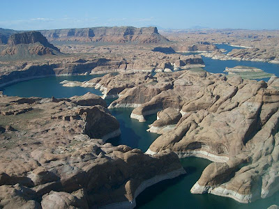
39 (D-92)Lake Powell is the second largest man-made lake in the United States and is without doubt the most scenic. It stretches 299 kilometers (186 miles) across the red rock desert from Page, Arizona to Hite, Utah. Utah has the lion's share of Powell's crystal clear water, but Arizona has the most important part—the dam. It took 17 years, from March 13, 1963 to June 22, 1980, to fill to the planned level of 1128 meters above sea level. Lake Powell contains 30 km³ of water when it is full. (The level has gone down since 2000 because of drought.) In 1972 Lake Powell and the surrounding countryside was incorporated into Glen Canyon National Recreation Area. There are 96 major canyons to explore but you'll need a boat for the majority of them because there are few roads. Other lake activities include swimming, fishing, scuba diving, snorkeling, water skiing, hiking and sightseeing.


The reservoir is named for explorer John Wesley Powell, a one-armed American Civil War veteran who explored the river in three wooden boats in 1869.


Jane
___________________________
VOCABULARY
-scenic = "qui offre de beaux paysages"
the lion's share = the biggest part
-level = "niveau"
-drought = "secheresse"; pronounced like the preposition "out"
-scuba diving = an underwater activity where you use diving cylinders (Br) diving tanks or scuba tanks (Am) to breathe
-snorkeling = to move or swim underwater using a snorkel which is a breathing tube extending above the surface of the water, used in swimming just below the surface
___________________________
What is the largest man-made lake in the United States and where is it?
What does "scuba" stand for? (Hint: "u"= underwater; "b" = breathing)

Sunday, February 7, 2010

38 (D-93) Glen Canyon Dam/ Lake Powell

38 (D-93) Page has become the gateway to the Glen Canyon National Recreation Area and Lake Powell, attracting more than 3 million visitors per year.


The Glen Canyon Dam is a dam on the Colorado River at Page, Arizona. It provides water storage for the arid southwestern United States, to generate electricity for the region's growing population, and to provide water recreation opportunities. The dam generates 6% of the total electricity generated in Arizona and 13% of that generated in Utah where most of Lake Powell lies.

Page is in fact the home of two of the largest electrical generation units in the western United States. Glen Canyon Dam has a 1,288,000 kilowatts capacity when fully online. The other power plant to the southeast is the Navajo Generating Station, a coal-fired steam plant with an output capability of 2,250,000 kilowatts.


Damming the Colorado river flooded Glen Canyon and created a large reservoir called Lake Powell.


Jane
________________________________
VOCABULARY
gateway = entrance
dam = "barrage"
coal = "charbon"
steam = "vapeur"

Saturday, February 6, 2010

37 (D-94) Page

37 (D-94)Page, Arizona (population 6794) was created in 1957 to house the workers and their families during the construction of nearby Glen Canyon Dam on the Colorado River. Its 44 km2 site was obtained in a land exchange with the Navajo Indian tribe. The tribe was given land in New Mexico in exchange for this site that would become Page, a city perched atop Manson Mesa (a mountain summit) at an elevation of 1300 m and 180 m above Lake Powell.

Did you know that parts of the 1968 film The Planet of the Apes were shot here around Page?

Why is the city called "Page"?

Jane

Friday, February 5, 2010

36 (D-95) [Day 6] Antelope Canyon


We leave Flagstaff again on the morning of our sixth day. This time we’ll be heading north, to go to Page, Arizona, 218 km from Flagstaff. First, we'll visit Antelope Canyon, east of Page.

36 (D-95) Antelope Canyon. What a beautiful place!

If you like, take a look: http://www.arizona-leisure.com/antelope-canyon.html
You can click on the video there. There's also a map on this site. Double-click on the video and on the map to make them bigger.

Antelope Canyon is the most-visited and most-photographed slot canyon in the American Southwest. It is located on Navajo land near Page, Arizona. Antelope Canyon includes two separate, photogenic slot canyon sections: 1) Upper Antelope Canyon or The Crack and 2) Lower Antelope Canyon or The Corkscrew. The Navajo name for Upper Antelope Canyon is Tse' bighanilini, which means "the place where water runs through rocks." Lower Antelope Canyon is Hasdestwazi, or "spiral rock arches."
Antelope Canyon is a popular place for photographers and sightseers, and a source of tourism business for the Navajo Nation. It has been accessible by permit only since 1997, when the Navajo Tribe made it a Navajo Tribal Park. Photography within the canyons is difficult because of the light reflecting off the canyon walls.
Flooding in the canyon still occurs. A flood occurred on October 30, 2006 that lasted 36 hours, and caused the Tribal Park Authorities to close Lower Antelope Canyon for five months.


Jane
_________________________
VOCABULARY:
--slot canyon = A slot canyon is a narrow canyon, formed by water rushing through rock. A slot canyon is significantly deeper than it is wide. Some slot canyons can measure less than one metre (3 ft) across at the top but drop more than 30 m (100 ft) to the floor of the canyon.
--What is a "corkscrew"? What is "The Corkscrew" in New York City??
--occurs = happens
--floods, flooding = look in your dictionary or go to http://www.thefreedictionary.com/

Thursday, February 4, 2010

35 (D-96) The Sinagua people


35 (D-96) The Sinagua were a pre-Columbian cultural group living in an area in central Arizona between the Little Colorado River and the Salt River (between Flagstaff and Phoenix). They lived there between approximately 500 AD and 1425 AD. Sinagua comes from the Spanish words sin meaning "without" and agua meaning "water", referring to the name originally given to the San Francisco Peaks by Spanish explorers. These mountains near Flagstaff, Arizona, are called the "Sierra Sin Agua". Several Hopi clans trace their roots to immigrants from the Sinagua culture.

Along The Island Trail in Walnut Canyon, you can see 25 cliff dwelling rooms. More are visible across the canyon. A typical room was perhaps for one family and perhaps it measured approximately two meters high, six meters long and three meters deep. The Sinagua left these dwellings about 700 years ago.

Jane
___________________________

After a date, what do these letters "AD" stand for? What do the letters "BC" stand for? ("to stand for" = "to mean")
What is the meaning of "BCE"?

Wednesday, February 3, 2010

34 (D-97) Walnut Canyon

34 (D-97) Walnut Canyon National Monument is a United States National Monument located about 16 km southeast of downtown Flagstaff, Arizona. Walnut Canyon lies on the Colorado Plateau. The canyon rim is at an elevation of 2,040 m; the canyon's floor is 107 m lower. A 1.4 km long loop trail descends 56 m into the canyon passing 25 cliff dwelling rooms constructed by the Sinagua people. Walnut Canyon was proclaimed a national monument on November 30, 1915.

Jane
_________________________________
We have just learned that American astronauts will not return to the moon as planned if Congress passes President Obama's proposed budget. During the 1960s, NASA astronauts trained for missions to the moon at Meteor Crater in Arizona.